You’re looking for a drone that’ll deliver centimeter-level accuracy for your precision work. Whether you’re mapping terrain, inspecting infrastructure, or collecting critical data, you’ve got serious requirements. The right RTK-enabled model can transform your operations—but not all drones are created equal. Let’s explore which ones truly stand out and why.
Quick Overview
- RTK drones deliver 1-2 cm horizontal accuracy and 2-3 cm vertical accuracy, essential for surveying and precision mapping applications.
- Flight endurance of 38-49 minutes with swappable batteries enables continuous missions and extended coverage for large surveying projects.
- Triple and dual-camera systems with thermal imaging, 6K video, and 48MP resolution support diverse professional applications and data quality.
- Transmission ranges of 15-25 km with advanced RF protocols ensure stable connectivity across challenging terrain for remote operations.
- Professional-grade RTK systems range from $5,000 to $50,000+, requiring careful evaluation of features against application-specific accuracy and imaging needs.
| Autel Robotics EVO II PRO RTK V3 Drone |
| Best Overall | Camera Resolution: 6K/30fps HDR | Flight Time: 38 minutes | Transmission Range: 15 km | VIEW LATEST PRICE | Read Our Analysis |
| DJI Matrice 4E Drone (No Care) |

| Longest Flight Time | Camera Resolution: 20MP wide, 48MP telephoto | Flight Time: 49 minutes (standard), 46 minutes (low-noise) | Transmission Range: 25 km (FCC) | VIEW LATEST PRICE | Read Our Analysis |
| Autel Robotics EVO Lite 640T Enterprise Thermal Drone |

| Best Thermal Imaging | Camera Resolution: 640×512 thermal, 48MP visible | Flight Time: 40 minutes max | Transmission Range: 12 km | VIEW LATEST PRICE | Read Our Analysis |
| Autel Robotics EVO II Dual 640T Thermal Imaging Drone |

| Advanced Thermal Capabilities | Camera Resolution: 640×512 thermal, 50MP 8K visible | Flight Time: 38 minutes | Transmission Range: 15 km | VIEW LATEST PRICE | Read Our Analysis |
| GPS Drone with 4K Camera & Foldable Design |

| Budget-Friendly Pick | Camera Resolution: 4K with 110° wide-angle | Flight Time: Not specified | Transmission Range: 985 feet (~300 meters) | VIEW LATEST PRICE | Read Our Analysis |
| Drone with 4K Camera GPS & 70 Min Flight |

| Best For Beginners | Camera Resolution: 4K with 130° wide-angle | Flight Time: 70 minutes | Transmission Range: Not specified | VIEW LATEST PRICE | Read Our Analysis |
| DJI Mini 3 Lightweight 4K Camera Drone with GPS |

| Most Portable | Camera Resolution: 4K UHD | Flight Time: 51 minutes (with Plus battery) | Transmission Range: 10 km | VIEW LATEST PRICE | Read Our Analysis |
More Details on Our Top Picks
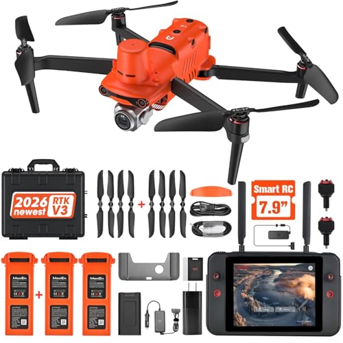
Autel Robotics EVO II PRO RTK V3 Drone
If you’re mapping large areas or conducting surveys that demand centimeter-level accuracy, the Autel Robotics EVO II PRO RTK V3 delivers the precision you need. This UAV achieves 1 cm + 1 ppm horizontal positioning through RTK base station and network support, independent of communication links. You’ll capture 6K/30fps HDR video with its Sony 1″ camera while enjoying 38 minutes of flight time and 15KM transmission range. The drone supports waypoint, polygon, and oblique photography missions, plus it records flight paths for repeatable data acquisition. Its compatibility with Carlson software makes it ideal for mapping, photogrammetry, and urban planning projects across firefighting, search and rescue, and infrastructure inspection applications.
- Camera Resolution:6K/30fps HDR
- Flight Time:38 minutes
- Transmission Range:15 km
- Positioning System:RTK base station and RTK network, 1cm + 1ppm horizontal accuracy
- Portability:Compact with 3 batteries included
- Autonomous Flight Modes:Waypoint, rectangle, polygon, oblique photography missions
- Additional Feature:1cm + 1ppm positioning accuracy
- Additional Feature:Sony 1″ 6K HDR camera
- Additional Feature:15km transmission range
DJI Matrice 4E Drone (No Care)
You’ll find the DJI Matrice 4E an exceptional choice if you’re prioritizing professional-grade imaging and extended flight capabilities. With up to 49 minutes of flight time using standard propellers, you’ll cover expansive areas without frequent battery changes. The drone’s triple-camera system—20MP wide and dual telephoto lenses at 48MP—lets you capture intricate details from varying distances. Its RTK positioning delivers hovering accuracy within ±0.1 meters, ensuring consistent precision for surveying and mapping tasks. The omnidirectional binocular vision paired with 3D infrared sensing provides thorough obstacle avoidance. You’ll also benefit from a 25-kilometer transmission range in ideal conditions, enabling operations across substantial distances with reliable connectivity and control.
- Camera Resolution:20MP wide, 48MP telephoto
- Flight Time:49 minutes (standard), 46 minutes (low-noise)
- Transmission Range:25 km (FCC)
- Positioning System:GNSS and RTK, +/-0.1m hovering accuracy
- Portability:Not specified
- Autonomous Flight Modes:Not specified
- Additional Feature:Omnidirectional binocular vision system
- Additional Feature:48MP telephoto camera capabilities
- Additional Feature:25km maximum transmission distance
Autel Robotics EVO Lite 640T Enterprise Thermal Drone
The Autel Robotics EVO Lite 640T stands out as the ideal choice for professionals who need thermal imaging without sacrificing portability. You’ll appreciate its 640×512 thermal resolution at 30 FPS, delivering superior clarity compared to competing models in its class. The 48-megapixel visible light camera with a 3-axis gimbal captures stable, high-quality video from multiple perspectives. Weighing just 866g, you can deploy it quickly for inspections, search and rescue, or infrastructure assessments. Its SkyLink 2.0 transmission reaches 12km, while the intelligent controller displays at 800 nits brightness. With 40-minute flight endurance and 17m/s max speed, you’ll cover substantial ground efficiently while maintaining the precision RTK professionals demand.
- Camera Resolution:640×512 thermal, 48MP visible
- Flight Time:40 minutes max
- Transmission Range:12 km
- Positioning System:GPS positioning
- Portability:Compact and lightweight, 866g
- Autonomous Flight Modes:AI target recognition via Autel Enterprise App
- Additional Feature:640×512 thermal imaging resolution
- Additional Feature:AI target recognition positioning
- Additional Feature:6-inch Smart Controller display
Autel Robotics EVO II Dual 640T Thermal Imaging Drone
Professionals managing complex inspection operations—from power grids to industrial facilities—will find the Autel Robotics EVO II Dual 640T indispensable with its dual-camera system combining a 640×512 thermal sensor and 50MP visible camera. You’ll leverage 10+ temperature measurement modes for precise thermal analysis across search and rescue, firefighting, and oil rig inspections. The drone delivers 38-minute flight times with SkyLink 2.0’s 15km transmission range, ensuring you’re never disconnected. Its 19 integrated sensor groups enable sophisticated 3D mapping and autonomous path planning, while advanced subject recognition at 100m enhances operational safety. You’re equipped with professional-grade tools that streamline critical decision-making in high-stakes environments.
- Camera Resolution:640×512 thermal, 50MP 8K visible
- Flight Time:38 minutes
- Transmission Range:15 km
- Positioning System:GNSS/visual positioning with 19 sensor groups
- Portability:Not specified
- Autonomous Flight Modes:3D mapping and path planning, No Fly Zone Function
- Additional Feature:10+ temperature measurement modes
- Additional Feature:50MP 8K RYYB sensor
- Additional Feature:19 sensor groups integrated
GPS Drone with 4K Camera & Foldable Design
For hobbyists and casual users who want professional-quality aerial photography without the complexity, this foldable GPS drone combines accessibility with impressive performance. You’ll appreciate the 4K camera with its 110° wide-angle lens and electronically adjustable 90° angle, capturing stunning photos and videos effortlessly. The GPS Return-to-Home function and Follow/Circle Fly modes give you confidence during flights. Brushless motors guarantee excellent wind resistance, while dual positioning systems lock your location precisely. You get stable transmission up to 985 feet and maximum flight distance of 1640 feet. Beginner mode and one-key controls simplify operation, and two included batteries extend your flying sessions.
- Camera Resolution:4K with 110° wide-angle
- Flight Time:Not specified
- Transmission Range:985 feet (~300 meters)
- Positioning System:GPS with Return-to-Home
- Portability:Foldable design with carrying case
- Autonomous Flight Modes:GPS Follow and Circle Fly modes
- Additional Feature:Gesture mode photo/video
- Additional Feature:GPS Follow and Circle
- Additional Feature:985 feet video transmission
Drone with 4K Camera GPS & 70 Min Flight
If you’re seeking extended flight time without sacrificing portability, this 4K drone delivers an impressive 70-minute runtime from dual modular batteries—a significant advantage for mapping projects and extended surveying missions. You’ll appreciate the 4K camera with its 130° wide-angle lens and 90° adjustable tilt, capturing detailed imagery at 3840×2160 resolution. The GPS-enabled smart navigation features—including Waypoint Fly, Follow Me, and automatic return-to-home functions—streamline your workflow. At under 249g with a foldable design, you’re gaining professional-grade capabilities in a portable package. USB-C fast charging keeps you operational, while brushless motors and Level 5 wind resistance guarantee reliability in challenging conditions.
- Camera Resolution:4K with 130° wide-angle
- Flight Time:70 minutes
- Transmission Range:Not specified
- Positioning System:GPS with Smart Return to Home
- Portability:Under 249g, foldable design
- Autonomous Flight Modes:Follow Me, Waypoint Fly, Circle Flight
- Additional Feature:130° wide-angle lens
- Additional Feature:EIS image stabilization
- Additional Feature:Level 5 wind resistance
DJI Mini 3 Lightweight 4K Camera Drone with GPS
The DJI Mini 3 stands out as an exceptional choice for hobbyists and casual creators who want professional-grade imaging without regulatory hassles. You’ll appreciate its sub-249g weight, eliminating registration requirements in most regions. The drone delivers 4K UHD video with Dual Native ISO Fusion, capturing impressive detail in both highlights and shadows. You can shoot vertically for tall subjects and enjoy up to 51 minutes of flight time with the Intelligent Flight Battery Plus. Its 3-axis mechanical gimbal stabilizes footage while you fly in winds up to 38 kph. GPS Return to Home and precise hovering guarantee safe, reliable operation. With 10 km HD video transmission and the included DJI RC controller featuring a 5.5-inch display, you’ll command complete control over your creative vision.
- Camera Resolution:4K UHD
- Flight Time:51 minutes (with Plus battery)
- Transmission Range:10 km
- Positioning System:GPS with Return to Home
- Portability:Under 249g, no registration needed
- Autonomous Flight Modes:Not specified
- Additional Feature:Dual Native ISO Fusion
- Additional Feature:True Vertical Shooting capability
- Additional Feature:51 minutes extended battery
Factors to Consider When Choosing a Drone With RTK
When you’re selecting an RTK drone, you’ll want to evaluate your positioning accuracy requirements first, as they’ll determine which system suits your specific surveying or mapping needs. You should also weigh flight time and endurance against camera capabilities and transmission range to guarantee the drone handles your job site’s size and complexity. Finally, compare your budget against the value each model offers, balancing advanced features with affordability.
Positioning Accuracy Requirements
Because your drone’s RTK system’s effectiveness depends directly on meeting your application’s accuracy demands, you’ll need to understand what positioning precision your specific use case requires. Different projects demand different accuracy levels. Mapping and surveying typically need centimeter-level precision, while inspection work might tolerate slightly broader tolerances. RTK drones deliver horizontal accuracies of 1-2 cm and vertical accuracies of 2-3 cm, making them suitable for most professional applications. However, you should evaluate whether your project genuinely requires this precision or if standard GPS suffices. Consider your operating environment too—satellite visibility, baseline distance to your RTK base station, and atmospheric conditions all influence actual achievable accuracy. Matching your accuracy requirements to the right RTK system prevents overspending on unnecessary capability.
Flight Time and Endurance
Flight time and endurance directly impact your drone’s operational capability and mission success. You’ll want to evaluate how long your RTK drone can stay airborne to complete extensive surveys and data collection without interruption.
Battery capacity and propulsion efficiency are critical factors that determine your endurance. A lightweight design also extends flight duration considerably. However, real-world conditions matter—weather, flight modes, and payload weight all reduce actual flight time compared to manufacturer specs.
Consider swappable batteries for your operations. Quick battery changes enable continuous missions and extended coverage without lengthy downtime. This flexibility becomes invaluable when you’re managing large surveying projects or multiple sites in a single day, maximizing your productivity and return on investment.
Camera and Imaging Specs
Your RTK drone’s imaging capabilities will make or break your data quality and mission success. You’ll want to evaluate sensor size, megapixel count, and lens quality as your foundation for reliable imagery.
Consider your specific needs: 4K or 6K video capture, low-light performance, and image stabilization enhance versatility across diverse conditions. If you’re conducting search and rescue, infrastructure inspection, or precision agriculture work, thermal imaging or multispectral data collection becomes invaluable.
Look for integrated processing features like real-time image stitching and automatic classification—they’ll streamline your workflow considerably. You’ll also benefit from checking software compatibility; guarantee your drone integrates seamlessly with third-party photogrammetry and mapping platforms. This compatibility transforms raw imagery into thorough geospatial datasets without extra processing headaches.
Transmission Range Capabilities
Once you’ve locked down your imaging specs, reliable data transmission becomes the next critical factor in your RTK drone selection. You’ll want a system that maintains stable connections over extended distances—typically 15 kilometers or more—without interruption. RTK drones employ advanced radio frequency protocols to sustain this reliability, even across challenging terrain and urban environments where line-of-sight isn’t guaranteed.
Consider whether you need directional antennas or signal boosters to extend range further, particularly for remote operations. Network-based RTK solutions offer additional flexibility for seamless connectivity. Uninterrupted communication is non-negotiable for precision work like surveying, mapping, and inspections, where data loss can compromise entire projects. Evaluate each drone’s transmission specifications against your specific operational requirements and deployment locations.
Budget and Value Comparison
RTK drone systems represent a substantial investment, with pricing often ranging from $5,000 to $50,000+ depending on specifications and manufacturer. You’ll want to carefully evaluate whether the RTK capabilities justify the higher cost for your specific applications. Compare pricing and features across manufacturers to find the most cost-effective option meeting your needs. Consider long-term value too—improved data quality and productivity gains can offset initial expenses. Don’t overlook subscription or service fees, such as network access charges, which factor into your total cost of ownership. By weighing these elements, you’ll determine if an RTK-enabled drone delivers genuine value or if a standard model better suits your budget and requirements.
Application-Specific Use Cases
Because different industries rely on drones for distinct purposes, you’ll need to match your RTK system’s capabilities to your actual mission requirements. Surveying demands centimeter-level accuracy, making RTK critical for precise mapping and boundary determination. Inspection work prioritizes image resolution and hover stability over extreme accuracy. Search and rescue operations require extended flight time and reliable GPS positioning in challenging terrain.
Your environment shapes these decisions too. Dense urban areas with tall buildings weaken GPS signals, so you’ll want sturdy RTK correction sources. Heavily forested regions create similar obstruction challenges. Open construction sites or agricultural fields allow reliable RTK performance with standard equipment.
Before selecting your drone, identify which factors matter most: accuracy thresholds, flight duration, payload capacity, and environmental constraints. This targeted approach guarantees you invest in capabilities you’ll actually use.